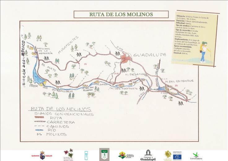
Starting from the Plaza Mayor, we will head towards the neighborhood of La Cantera or San José Obrero, through Nueva, Corredera and Cantera streets. We can also access the neighborhood through Avda. Alfonso XI and Molino de San Jerónimo street. Once past the Municipal Sports Center, we will take the lane that leads to Mato.
The route is flanked by rich vegetation: olive, chestnut and pine crops. We will also find short scrub and low forest scrub: rockrose, broom, bramble…
In addition, we will see Pico Agudo, the hermitage of Santa Catalina and, between the valleys of Hell and Valdegracia, Mirabel, with Pico Villuercas in the background
Following the course of the Guadalupe river, we will find the Molino de la Herrería mill, from where we will continue to the Mato dam. This is a good place to practice river fishing: trout, tench.
From the dam, we will go down to the Molino del Pan Blanco. Afterwards, we will continue until a fork, in the Bailadero area; taking the left path, we will arrive at the Batán de Arriba, a beautifully restored mill for country living.
Ascending, we will come to the regional road and, going down it, we will find the Molino del Martinete. Continuing along the road, we will travel about 2 km to the Batán de Abajo; A little further on, we will find the Molino de la Sierra
We will go to a crossroads and, after continuing 1 km in the direction of Alía, we will take the path to the left, past the bridge, and we will arrive at the Molino del Estanque, the last of our route
Finally, we will cross the Valhondo stream by a small bridge that will take us to the highway. Once there, we will walk to the right and return to the town along Avenida Juan Pablo II.
Note
The route can be divided into two sections:
Section A.- Molinos de Arriba. (Upper Mills)
Section B.- Molinos de Abajo. (Lower Mills)
